Preservation Society of Charleston – Charleston, S.C.

Preservation Society of Charleston - Charleston, S.C.

147 King Street

Charleston, SC
29403

843-722-4630

www.preservationsociety.org/

“Founded in 1920, the Preservation Society of Charleston is the oldest community based historic preservation organization in America. Our mission is to inspire the involvement of all who dwell in the Lowcountry to honor and respect our material and cultural heritage.”

Featuring:

  • Preservation Programs
  • Perservation Education
  • Fall Tours
  • Events
  • and more.
Get Directions

Old Slave MarOld Slave Mart Museum – Charleston, S.C.

Old Slave Mart Museum - Charleston, S.C.

Picture and Text Below Source – http://1.usa.gov/bYIbTy

6 Chalmers Street,
Charleston,
SC – 29401

843-958-6467

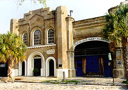
‘The Old Slave Mart, located on one of Charleston’s few remaining cobblestone streets, is the only known extant building used as a slave auction gallery in South Carolina. Once part of a complex of buildings, the Slave Mart building is the only structure to remain.

When it was first constructed in 1859, the open ended building was referred to as a shed, and used the walls of the German Fire Hall to its west to support the roof timbers.

Slave auctions were held inside.

The interior was one large room with a 20-foot ceiling, while the front facade was more impressive with its high arch, octagonal pillars and a large iron gate.

During the antebellum period, Charleston served as a center of commercial activity for the South’s plantation economy, which depended heavily upon slaves as a source of labor. Customarily in Charleston, slaves were sold on the north side of theExchange Building (then the Custom House)…

Around 1878, the Slave Mart was renovated into a two-story tenement dwelling. In 1938, the property was purchased by Miriam B. Wilson, who turned the site into a museum of African American history, arts and crafts.’

It is owned by the City of Charleston.

Hours – Monday-Saturday, 9:00am to 5:00pm.

Call 843-958-6467 for information.

Admission fees are charged.

1.usa.gov/bYIbTy

Get Directions

Old City Market Hall and Sheds – Historic Charleston, S.C.

Old City Market Hall and Sheds - Historic Charleston, S.C.

Picture Source – National Park Service

Corner of Market St. and Meeting St.,
Charleston,
SC – 29401
 
843-853-8000
www.thecharlestoncitymarket.com

‘Steeped in history and charm, the Charleston City Market is a popular destination for all who visit the Holy City.

Open 365 days per year, the Market is an exciting place for tourists and local Charleston residents alike.

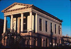
Market Hall stands facing Meeting Street as the main entrance to four blocks of open-air buildings.

Strolling through the Market you will encounter a wide assortment of vendors selling high quality products including paintings, pottery, Charleston’s famous sweetgrass baskets, casual and fine dining & more!’

PDF Map of Historic Charleston Market

Visitor Info

Source – http://bit.ly/9Eunay


Open 9 a.m. to 6 p.m. and sometimes later on weekend evenings.


Vendor contact information and more can be found on the City of Charleston Website
Source of text below – National Park Service


History of the Market –

‘The Market Hall and Sheds, a National Historic Landmark, are the only surviving market buildings in Charleston, and one of a small number of market complexes still extant in the United States.

The Market is also considered to be one of Charlestons best examples of Greek Revival style architecture, exemplified by its massive portico supported by Tuscan columns.

The buildings were constructed in 1840 to 41 and were designed by prominent local architect Edward Brickell White.

The Market was the commercial hub of Charleston for many years and is an important part of the city’s commercial heritage.’


Source – National Park Service


For more about the history of the market and the current occupancy visit the National Park Service Website ORWikipedia.

Get Directions

Gov. William Aiken House – a Landmark

Listed in National Register of Historic Places.

Gov. William Aiken House - a Landmark

Picture Source – National Park Service

Also known as The Aiken-Rhett House’.

48 Elizabeth St.,
Charleston,
SC – 29401
843-723-1159

The official Website.

Email

Features the only ‘audio tour’ in Charleston.

HOURS OF OPERATION

Monday-Saturday 10 a.m.-5 p.m

Sunday 2 p.m.-5 p.m.

Last tour begins at 4:15 p.m.

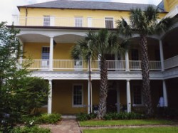
‘Completed in 1811, the William Aiken House is named after its first occupant, a successful Charleston merchant and president of the company that built South Carolinas first railroad.

The house is one of the best designed and crafted houses in the city and part of a national historic landmark district, along with its gardens, wrought-iron gates, and outbuildings that include a unique Gothic Revival-style carriage house.

The house was used for offices from 1877-2000, when it was converted into an event venue with offices and retail space.

The $3.7 million rehabilitation restored the houses original craftsmanship and design with help from an NPS Federal Historic Preservation Tax Credit.

Missing historic features in the first floor parlors were restored, and existing historic materials and finishes throughout the property were carefully conserved.

The property’s exceptional historic design can once again be fully appreciated by the community.’

Source – National Park Service

See also Wikipedia.

Get Directions

Fort Sumter – Charleston, S.C.

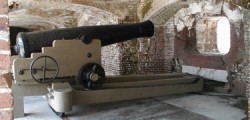
Fort Sumter is a federal fort in Charleston Harbor with a museum that tells the story of the fort’s role in the Civil War.

Ft. Sumter

‘Where The American Civil War Began

Decades of growing strife between North and South erupted in civil war on April 12, 1861, when Confederate artillery opened fire on this Federal fort in Charleston Harbor. Fort Sumter surrendered 34 hours later. Union forces would try for nearly four years to take it back.’

Source – Fort Sumter National Monument – U.S. Natonal Park Service Website
Fort Sumter - Charleston, S.C.

Picture Source – U.S. Natonal Park Service Website

The fort is constructed of over 70,000 tons and granite and rock.

There are three sites within the Fort Sumter National Monument – Charleston: the original Fort Sumter, Fort Sumter Visitor Education Center and Fort Moultrie on Sullivan’s Island.

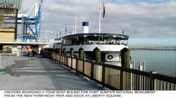
To visit Fort Sumter by RV or bus, we recommend taking the 30 minute ferry from the visitor center or Patriots Point Naval and Maritime Museum. ‘Their parking area can easily accommodate large vehicles. Parking for large vehicles in downtown Charleston is extremely limited, and the public parking garage has a clearance of 7’.

To visit Fort Moultrie by RV or bus, the parking area at the Fort Moultrie Visitor Center can accommodate your vehicle.’

‘You cannot get to Fort Sumter from Sullivan’s Island and Fort Moultrie.

Sullivans Island is the mailing address of the park and the location of Fort Moultrie and Park Headquarters.

Fort Sumter is located on an island in Charleston harbor and is only accessible by boat.

If you do not have access to a private boat, a concession-operated ferry is available.

The primary departure site is from the Fort Sumter Visitor Education Center located in downtown Charleston.

For departure schedules and fees, visit the concessioner page.

(SpiritLine Cruises is the concessioner – Their address is 360 Concord Street, Suite 201. – See Fort Sumter Tours – SpiritLine Cruises on CharlestonShines.com for more info)

The secondary departure site is located at Patriots Point in Mount Pleasant. Visitors with large vehicles such as buses and RVs should plan on using the Patriots Point departure site.

Fort Sumter Visitor Education Center
340 Concord Street
Charleston, South Carolina
843-722-2628

www.nps.gov/fosu/index.htm

Source – U.S. Natonal Park Service Website
Fort Sumter Tours

Picture Source – U.S. Natonal Park Service Website

Fort Sumter Area Map
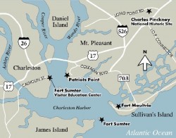
Fort Sumpter Area Map

Picture Source – U.S. Natonal Park Service Website
Drayton Hall – Southern Plantation in Charleston, S.C.

Drayton Hall - Southern plantation in Charleston, S.C.

Picture Source – http://www.draytonhall.org

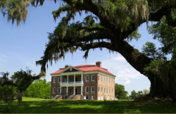
‘Drayton Hall is the closet plantation to Charleston. It is the only plantation home in Charleston not destroyed in the Civil War. The owners fled leaving the property to the slaves. The slaves saw smoke near Magnolia Plantation and put put yellow quarantine flags at the gate to make Union soldiers think there was malaria present.’  Adapted from article about Charleston by Judith Evans. 

‘Drayton Halls story spans three centuries of American History. It is the oldest surviving example of Georgian Palladian architecture in the U.S. and one of the only pre-Revolutionary houses that remain in close to original condition today.’ See DraytonHall.org for more. 

Open 7 days a week except major holidays.

Monday through Saturday: Main Gates: 9:00 a.m.-3:20 p.m. (Exit gate closes at 5 p.m.)

Museum Shop: 9:00 a.m.-4:45 p.m.

First Tour: 9:30 a.m.

Last Tour: 3:30 p.m.

House Tours: Starting on the half hour at 9:30am. Please arrive at least 20 minutes before the start of the tour.

  • Connections:  From Africa to America: 10:45 a.m., 12:45 p.m., and 2:45 p.m.
  • Voices of Drayton Hall:  An Interactive Landscape Tour on DVD: Available for complimentary rental throughout the day; enjoy at your own pace.

Sundays: Main Gates: 11:00 a.m.-3:20 p.m. (Exit gate closes at 5 p.m.)

Museum Shop: 11:00 a.m.- 4:45 p.m.

First Tour: 11:30 a.m.

Last Tour: 3:30 p.m.

House Tours: Starting on the half hour at 11:30am. Please arrive at least 20 minutes before the start of the tour.

‘To help ensure a thoroughly enjoyable experience:

Visitors wishing to take a house tour should arrive at the front gate at least 20 minutes before the start of the tour to allow for ticket transaction, parking, and check-in.

If a house tour is sold out, you will be offered the next available tour of your choice.In addition to the house tour, there are other daily activities and programs available, and all are included in the price of regular adult admission-just click on Things To Do in the right hand column.

You can also save time by purchasing your tickets here. Please note that all visitors must first stop at the front gate before entering the site.’

Get Directions

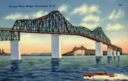
The Cooper River Bridge(s)

1939 Postcard of the Cooper River Bridge featured on American-Journal.org

Picture Source – http://american-journal.org/2012/01/cooper-river-bridge-charleston-s-c-c-1939/

The Cooper River Bridge is technically three bridges with separate names that served to transport Charlestonians over the years.

Its history is revealed on CooperRiverBridge.org  .  The three bridges are:

  1. The Grace Memorial Bridge – “The 2.71-mile bridge, later to be named the Grace Memorial Bridge, was built in just 17 months, at a total cost of approximately $6 million. It was opened with a three-day celebration on Aug. 8, 1929.”
  2. The Pearman Bridge – “In ceremonies on April 29, 1966, a new $15 million bridge over the Cooper River, parallel to the Grace Bridge, was opened to traffic, and dedicated in honor of Chief Highway Commissioner Silas N. Pearman.”
  3. The Ravenel Bridge (also known as the New Cooper River Bridge) – “Now the diamond towers of the Ravenel Bridge have been named the John P. Grace Tower and the Silas N. Pearman Tower to remember the men and the bridges that served Charleston.”
Be sure to visit the Mount Pleasant Pier at 71 Harry Hallman Boulevard in Mt. Pleasant.  It is a lovely park and gives you a great view of the bridges.  Here is what the Charleston Park and Recreation Commission says about it:

“Part of the Memorial Waterfront Park complex, the 1250-foot long Mount Pleasant Pier stretches out into Charleston Harbor under the foot of the Arthur Ravenel, Jr. Bridge. The pier’s foundation was created from pared-down pilings from the old Grace Memorial Bridge, and one end of the pier now features an 8,100-square-foot covered pavilion for hosting dances and other events. Visitors can enjoy beautiful views of the bridge and harbor from the pier’s bench swings and shade structures.”

Learn more about the bridges on the Wikipedia ‘Arthur Ravenel Jr. Bridge’ article. 

There are many, many beautiful images of the bridges on Google images –

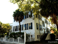
Gov. Thomas Bennett House – a Landmark – Charleston, S.C.

Photo Source – http://www.governorthomasbennetthouse.com/

Listed in National Register of Historic Places.

69 Barre Street,
Charleston, SC
WebsiteThe Governor Thomas Bennett House is available for rent during the day or evenings, for weekday or weekend events. The rental fee is for the use of the house and gardens.

‘It was built in approximately 1825 on land which had once belonged to architect and builder Thomas Bennett, Sr. (1754-1814).

Thomas Bennett, Sr.’s son, Thomas Bennett, Jr. (1781-1865), took over his father’s lumber and milling business but was also active in state and local politics.

He was superintendent of Charleston, South Carolina; a member of the South Carolina House of Representatives (and was its speaker from 1814 to 1818); a member of the South Carolina Senate; and governor of the state.

After his term as governor, Thomas Bennett, Jr. undertook the construction of this notable house on land which originally overlooked the rice and saw mills which he owned.

The house is a 2 1/2-story wooden structure on a high foundation of stuccoed brick.

The house has a single-story piazza with a fanlighted entrance, engaged columns, and entablature.

The house has a pediment on the south facade, a Palladian window, and round-headed stair window on the north side.

The interior is notable for its Regency style woodwork and plasterwork.

It also has a cantilevered stair which connects the first and second floor without visible means of support along the walls.

It is one of only two such stairs in Charleston, the other being the Nathaniel Russell House at 51 Meeting St.

The house’s floorplan is a basic double house.

Immediately behind the front door is a hall, separated from a rearward stair hall by a keystone arch and fanlighted doorway.’

Source – Wikipedia

Battery Cheves – a Landmark, James Island

Battery Cheves, named after after Capt. Langdon Cheves.   Cheves was a confederate engineer.  He was killed in 1863 at Morris Island.

The battery was listed in National Register of Historic Places in 1863.

The battery is located in a residential neighborhood, Fort Johnson Estates.

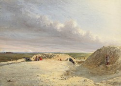
This is a great artist’s rendering of the Battery Cheves from the S.C. Battleground Trust and The Museum of the Confederacy in Richmond, Virginia.

The source for the following images –

http://www.nationalregister.sc.gov/charleston/S10817710129/index.htm

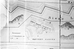
Battery Cheves Map

Battery Cheves

“Battery Cheves was built in 1863 and named for Capt. Langdon Cheves, Confederate engineer killed at Morris Island in 1863.

This battery was designed to protect the area between Fort Johnson and Battery Haskell from amphibious attack coming from Morris Island.

Cheves mounted two pieces of heavy artillery at the time of capture. Battery Cheves is located on the southeastern shore of James Island in a suburban residential area.

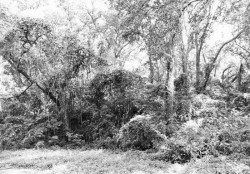
A simple open battery with four gun emplacements, Battery Cheves is about 280 feel long with a parapet 12.5 feet high and a powder magazine about 15 feet high.

The total position is approximately 240 feet deep. It is currently completely obscured by a dense growth of vegetation. Listed in the National Register August 11, 1982.

Source – http://www.nationalregister.sc.gov/charleston/S10817710129/index.htm

To learn more about Battery Cheves visit the following:

Get Directions