Weather is right for Charleston Water Taxi!
Beginning in Mid March the Charleston Water Taxi’s schedule expanded to daily from 9 am to 8 pm. Prior to that they were mostly open on Saturdays.
There are four departure points with different departing times. The four points are:
- Aquarium Wharf/MaritimeCenter
- Patriots Point Naval and Maritime Museum
- Charleston Harbor Resort and Marina
- Waterfront Park/Market St/Historic District
Morris Island and Morris Island Light
Picture and Text Source – http://en.wikipedia.org/wiki/Morris_Island
“Morris Island is an 840 acre (3.4 km²) uninhabited island in Charleston Harbor in South Carolina, accessible only by boat. The island lies in the outer reaches of the harbor and was thus a strategic location in the American Civil War.
Morris Island was heavily fortified to defend Charleston harbor…It was the scene of heavy fighting during the Union Army‘s campaign to captureCharleston, and is perhaps best known today as the scene of the ill-fated assault by the 54th Massachusetts Volunteer Infantry, an African-American regiment. The regiment and this assault, where it suffered over 50% casualties, was immortalized in the film Glory.”
After the Confederates abandoned Morris Island in 1863, the Union occupied it and transferred 520 Confederate officers from Fort Delaware to Morris Island… They were used as Human Shields…” Be sure to read on! http://en.wikipedia.org/wiki/Morris_Island and the article on the Morris Island Light
Picture Source – http://en.wikipedia.org/wiki/Morris_Island_Light
Fort Sumter – Charleston, S.C.
Fort Sumter is a federal fort in Charleston Harbor with a museum that tells the story of the fort’s role in the Civil War.
Ft. Sumter
‘Where The American Civil War Began
Decades of growing strife between North and South erupted in civil war on April 12, 1861, when Confederate artillery opened fire on this Federal fort in Charleston Harbor. Fort Sumter surrendered 34 hours later. Union forces would try for nearly four years to take it back.’
Source – Fort Sumter National Monument – U.S. Natonal Park Service Website
Picture Source – U.S. Natonal Park Service Website
The fort is constructed of over 70,000 tons and granite and rock.
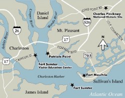
There are three sites within the Fort Sumter National Monument – Charleston: the original Fort Sumter, Fort Sumter Visitor Education Center and Fort Moultrie on Sullivan’s Island.
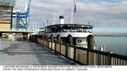
To visit Fort Sumter by RV or bus, we recommend taking the 30 minute ferry from the visitor center or Patriots Point Naval and Maritime Museum. ‘Their parking area can easily accommodate large vehicles. Parking for large vehicles in downtown Charleston is extremely limited, and the public parking garage has a clearance of 7’.
To visit Fort Moultrie by RV or bus, the parking area at the Fort Moultrie Visitor Center can accommodate your vehicle.’
‘You cannot get to Fort Sumter from Sullivan’s Island and Fort Moultrie.
Sullivans Island is the mailing address of the park and the location of Fort Moultrie and Park Headquarters.
Fort Sumter is located on an island in Charleston harbor and is only accessible by boat.
If you do not have access to a private boat, a concession-operated ferry is available.
The primary departure site is from the Fort Sumter Visitor Education Center located in downtown Charleston.
For departure schedules and fees, visit the concessioner page.
(SpiritLine Cruises is the concessioner – Their address is 360 Concord Street, Suite 201. – See Fort Sumter Tours – SpiritLine Cruises on CharlestonShines.com for more info)
The secondary departure site is located at Patriots Point in Mount Pleasant. Visitors with large vehicles such as buses and RVs should plan on using the Patriots Point departure site.
Fort Sumter Visitor Education Center 340 Concord Street Charleston, South Carolina 843-722-2628Source – U.S. Natonal Park Service Website
Picture Source – U.S. Natonal Park Service Website
Fort Sumter Area Map
Picture Source – U.S. Natonal Park Service Website
The Confederate Museum – Charleston, S.C.
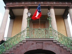 Photo source – http://www.csa-scla.org/articles/ConfederateMuseum.htm
188 Meeting Street
Charleston,
SC – 29401
843-723-1541
The Confederate Museum is located above the open-air market a National Historic Landmark
Hours of Operation: Tuesday – Saturday 11AM – 3:30PM, Closed on Sundays and Mondays/ Call to verify hours and days.
Admission: Adults & Teens $5.00—-6 – 12 years old $3.00, Under 6 Free
Built in 1841.
Contains the Daughters of the Confederacy Museum.
During the Civil War the hall was a recruiting station.
Features Greek Revival-style architecture.
The museum has a library, exhibits and artifacts of the confederacy.
Donations Always Welcomed ~
Mail to: Confederate Museum
P.O. Box 20997
Charleston, SC 29413
Find out more…http://www.csa-scla.org/articles/ConfederateMuseum.htm
Battery Cheves – a Landmark, James Island
Battery Cheves, named after after Capt. Langdon Cheves. Cheves was a confederate engineer. He was killed in 1863 at Morris Island.
The battery was listed in National Register of Historic Places in 1863.
The battery is located in a residential neighborhood, Fort Johnson Estates.
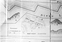
This is a great artist’s rendering of the Battery Cheves from the S.C. Battleground Trust and The Museum of the Confederacy in Richmond, Virginia.
The source for the following images –
http://www.nationalregister.sc.gov/charleston/S10817710129/index.htm
“Battery Cheves was built in 1863 and named for Capt. Langdon Cheves, Confederate engineer killed at Morris Island in 1863.
This battery was designed to protect the area between Fort Johnson and Battery Haskell from amphibious attack coming from Morris Island.
Cheves mounted two pieces of heavy artillery at the time of capture. Battery Cheves is located on the southeastern shore of James Island in a suburban residential area.
A simple open battery with four gun emplacements, Battery Cheves is about 280 feel long with a parapet 12.5 feet high and a powder magazine about 15 feet high.
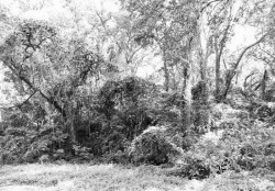
The total position is approximately 240 feet deep. It is currently completely obscured by a dense growth of vegetation. Listed in the National Register August 11, 1982.”
Source – http://www.nationalregister.sc.gov/charleston/S10817710129/index.htm
To learn more about Battery Cheves visit the following:
